0724-1708 29 March 2012 South Bimini to Northwest Shoal, Great Bahama Bank, Bahamas 66nm (75.9sm)
With light winds predicted for the next several days, the marina almost emptied out. As we headed out we saw the sailing vessel
TENACIOUS, a square rigger at anchor.
 |
| Square rigger TENACIOUS |
She is outfitted to accommodate people with disabilitities.
We were traveling with 4 other boats today. By the end of the day the pack would have left us in the dust to press on for Chubb Cay and Nassau. We decided to anchor on the Great Bahama Bank at Northwest Shoal.
As sundown approached there were two other boats within sight. Once it was dark it was amazing to see how many anchor lights popped up on the bank. The water is as clear as the water in your bathtub – you can see the anchor chain lying in the sand.
 |
| Anchor and anchor chain on the bottom of 15.5' water |
0824-1620 30 March 2012 Northwest Shoal to West Bay, New Providence, Bahamas 49nm (56.35sm)
As we got underway this morning we discovered that two other boats from Bimini Sands Marina, S/V Anam Cara and S/V Side by Side, had also anchored on the bank.
Since the Exumas is our primary destination, we decided to catch Nassau on the way back. Armed with a BTC (Bahamas Telephone Communications) SIM card and “minute cards” for my unlocked smartphone we had no immediate reason to stop in Nassau, The smartphone will allow us to get Chris Parker’s weather forecast while we are in the Bahamas. More specifically whenever we are in sight of a Bahamas Telephone Communications tower. Matt & Marty, S/V Runaway, recommended an unlocked smartphone and subsequently guided me through the mechanics of setting up the data service with BTC. Thanks for your help!
Heading off the Great Bahama Bank onto the Tongue of the Ocean, the depth sounder went from 15-20’ in a matter of yards to hundreds of feet and then over a thousand feet deep. The water is a beautiful shade of midnight blue. We headed toward the west end of New Providence to anchor for the night. The chart shows numerous coral heads fringing the bay. I don’t think I’d know a coral head from a big rock but here I was on the bow looking for something big breaking the surface. Fortunately I didn’t see anything and we anchored without incident.
 |
| West Bay, New Providence (Nassau) shoreline |
 |
| West Bay, New Providence (Nassau) shoreline |
View Larger Map
Hopefully the green arrow shows you where we anchored in West Bay. We were at the extreme west end of New Providence island. Zoom in for more detail. Note the Tongue of the Ocean at top left. That is where we left the bank and entered the ocean.
0750-1541 31 March 2012 West Bay, New Providence to Norman’s Cay, Exumas 51nm (58.65sm)
Another beautiful day on the water! The clarity of the water is unmatched. Nothing I’ve seen before begins to compare with what we’ve encountered here. Beautiful hues of blue showcase the various water depths and are offset by sandbars and darker shallower areas (brown, brown, run aground!). As we head into the anchorage we are skirting “shifting” sandbars! We anchor and celebrate our first anchorage in the Exumas.
1-2 April 2012 Anchored as before Norman’s Cay, Exumas
A slight increase in the westerly winds made the anchorage slightly rolly –nothing uncomfortable but getting off the swim platform of the boat into the dinghy was an exercise in timing and coordination for me. We set off to explore our new surroundings. We found our way back into Norman’s Cut, a beautiful anchorage protected from all but strong easterly winds.
 |
| Ted - Norman's Cay |
We met folks on the
Yamacraw, a Chesapeake buyboat. This gentleman has owned the boat for over 30 years.
 |
| Chesapeake buyboat Yamacraw in Norman's Cut |
You just never know who you will meet! We headed over to McDuff’s for a burger and a beer only to learn that the restaurant and bar were closed. Well, it was Palm Sunday after all….
 |
| Nancy - Entrance to bar & restaurant on Norman's Cay |
Monday we dinghied back to Wax Cay to check out the Way Cay Resort.
 |
| Wax Cay Resort |
Returning to Norman’s Cut after that we checked out the sunken airplane that is a remnant from the days of very profitable cocaine smuggling operation from Norman’s Cay back in the 70’s and 80’s. This kids in the dinghy were being pulled around by their parents who were snorkeling around the plane.
 |
| Sunken aircraft - Norman's Cut |
 |
| Aloha Friday anchored on the west side of Norman's Vay |
 |
| How about that water? |
1120-1258 2 April 2012 Norman’s Cay to Shroud Cay, Exumas 8nm (9.2sm)
As we departed Norman’s Cay we skirted around the shifting sandbars and Norman’s Bar (a sandbar) enroute to Shroud Cay. We towed the dinghy astern. Shroud Cay is part of the Exumas Land & Sea Park, one of 26 national parks managed by the Bahamas National Trust. Shelling, lobstering, conching and fishing are not permitted. It was hard to imagine we could find a prettier spot than Norman’s Cut but at the end of the northern creek than runs through the mangroves, it opened up into a 15’ pool which spills out onto an absolutely picture perfect beach. Have I stepped out of a scene from the movie, From Here to Eternity?
 |
| Mangroves - Shroud Cay |
 |
| Shroud Cay beach - Exuma Sound side |
 |
| Shroud Cay |
Back in the anchorage we’d already noticed several large yachts anchored. When we watched this guy anchor right in our back yard, I was beginning to feel like I was in the wrong neighborhood.
 |
| M/Y Vava |
 |
| M/Y Latitude and M/Y Meridian - family owned yachts |
At night the larger yachts display a variety of lighting schemes about
the boat. Two, Meridian and Latitude, were moored together. I also
noted that I forgot all the toys necessary for a trip in this region –
paddleboards, jet ski’s, etc. I did remember my noodle and my snorkel!
As we absorbed the sights and sounds around us we discovered nesting white tailed tropic birds on the small island close by and lots of curly tailed lizards on the rock and sand paths. The tropicbirds put on quick a show with their acrobatics.
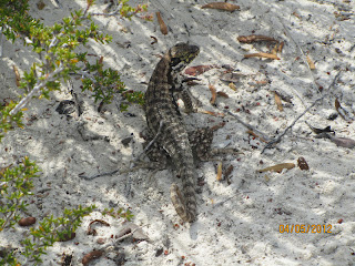 |
| Curly tailed lizards |
 |
White tailed tropicbirds
|
 |
| Ted cleaning the bottom of the boat - blue object is the stabilizer |
We reconnected with new friends, Carol and Dan Rohr (M/Y Lucky Stars), the next day.
0947-1320 4 April 2012 Shroud Cay to Warderick Wells North Mooring Field, Exumas 18 nm (20.7 sm)
Another gorgeous day on the water running down to Warderick Wells. Lots of boats are on the move when the winds are light. We have a reservation for a mooring ball here in the popular north mooring field. It took me awhile to get the pennant for the mooring ball up as it had no float and the line was one of the heaviest I’ve encountered on a mooring ball. Nonetheless after my third try I had a line through the eye on the pennant and we were secured. Naturally I couldn’t have done any of this if Ted hadn’t kept the bow right on top of the mooring ball!
Here are a few photos of the mooring field as well as photos from our hikes around the
Exuma Cays Land and Sea Park (ECLSP). We have been here 5 days now. This is really a beautiful place!
 |
| North mooring field - Warderick Wells |
If you look hard, you can see
Aloha Friday just to the right of center. The darker blue water is the deeper water.
 |
| Aloha Friday - North mooring field ECLSP |
We went on a 4 hour hike that took us over to the Exuma Sound side down toward Hog Cay mooring field and back over to the Exuma Bank side overlooking the Emerald Rock mooring field. Some of the photos from the hike follow....
 |
| Ted - Exuma Sound side |
 |
| Nancy - Exuma Sound side |
 |
| Hog Cay mooring and anchorage |
It was fairly windy on the Sound but calm and flat inside Hog Cay.
 |
| Guess who? |
 |
| Loyalist-built wall crosses island |
This wall was built by Loyalists (folks who did not support the American Revolution and emigrated to the Bahamas). We estimate that it was about 3' high and ran a little over .1 mile. Rock is plentiful on the island so they had plenty of resources with which to work.
 |
| Overlooking Emerald Rock mooring field |
 |
| Taking the shortcut home.... |
At one point in what turned out to be a long hike it looked like we were gong to have to backtrack. It was low tide so we took a short cut across a couple small bays. Even in water this shallow there were small anemones and live shells. Being the wimp that I am I was being careful not to step on any foreign objects!
You can't see the water since it is gin-clear but at low tide we observed
4 rays in a tide pool skimming around. There were also small aquarium
size fish and live conchs. We watched one of them moving using its
foot.
 |
| Rays in the tide pool |
 |
| Conch shells -all live sitting in a tide pool |
On another hike where we took the long route to Boo Boo Hill, we saw several collections of shells along the way on the beach side of Exuma Sound .
 |
| Conch Shells |
Exuma Park is a "no take" zone. It is not uncommon to see collections of shells or sea fans along the paths.
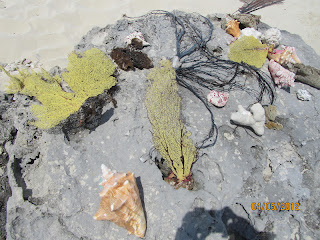 |
| Sea fan, shells and coral |
 |
| ECLSP coastline - Exuma Sound side |
 |
| Boo Boo Hill - Exuma Park |
Cruisers can leave a piece of driftwood with their boat name on it. We looked for several boats who precede us here but only found the maker from
M/Y Lucky Stars in 2010.
 |
| North mooring field |
Note the sandbar on this side of the photo. You can walk here at low tide.
On a separate note, we had an unannounced visitor show up on the boat and enter the salon uninvited. The bird below is lucky the cats are 19 years old! Once the bird had a look around, it started looking for an exit.
To wind up this blog, here's a nice google map of Warderick Wells. The mooring field shows up nicely here. It is that crescent shaped arc of darker water.


Great photos Nancy! Looks absolutely wonderful! We are very jealous of that beautiful water! Yeah a playmate for the cats!
ReplyDelete